Wild Website: Nationalatlas.gov
I discovered this amazingly cool website today and just had to share it will you all. Check out this map making website. It has so many cool subjects that you can use to make a GIS map. Here is a photo of one I made that shows the ecoregions of the lower 48.

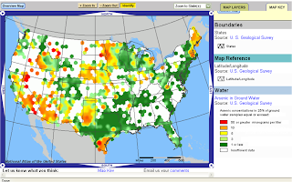

This one shows the levels of arsenic in groundwater.

I looked at maps of agriculture, pollution, federal ownership, health, and tons of other stuff. You can zoom into a state or out to the whole 50 states. If you want more details about any of the 'colors' on your map you can click the "map key" at the bottom center of the map or just click the color and a pop up box gives you great details. When I looked at all the wilderness areas in the country, I clicked on a specific one and got great info and a link to Wilderness.net for even more info.
If you are a map lover like me and are fascinated by where 'things' are then you will love this. One problem though is that you cannot always overlap maps like in a true GIS fashion. Some of the elements get hidden behind the others and I haven't figured out how to show the multiple layers easily.
Check out the site and tell me what your favorite map was.


Uh oh...maps. Must. Resist.
ReplyDeleteTalk about something I can spend hours doing!
No...must go do laundry...now! ;)
Just you wait...I've got another map website to share with everyone. Mwahh ha ha ha!
ReplyDeleteAnd of course you can always just get lost in Google Earth and look at all the bigfoot siting locations they have listed.